莱特省
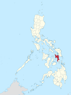
莱特省(宿务语:Amihanang Leyte;瓦瑞语:Norte san/Amihanan nga Leyte;他加禄语:Lalawigan ng Leyte)也称北莱特省,闽南语又译作礼智省,是菲律宾东米沙鄢大区下的一个省份,位于莱特岛,约占该岛3/4的面积,北邻比利兰省,南接南莱特省,西隔卡莫特斯海与宿务省相望,东隔圣华尼科海峡与萨马岛相望,首府为独鲁万市。
| 莱特省 | |||
|---|---|---|---|
| Amihanang Leyte | |||
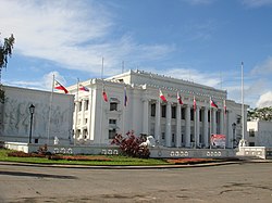
 莱特省议会大厦 | |||
| |||
 莱特省在菲律宾的位置 | |||
| 坐标:11°00′N 124°51′E / 11.000°N 124.850°E坐标:11°00′N 124°51′E / 11.000°N 124.850°E | |||
| 国家 | |||
| 大区 | 西米沙鄢(第6政区) | ||
| 成立时间 | 1735年[1] | ||
| 首府 | 独鲁万市 | ||
| 政府 | |||
| • 省长 | Leopoldo Petilla(菲律宾民主党–人民力量) | ||
| • 副省长 | Carlo Loreto(菲律宾自由党) | ||
| • 国会代表 | 国会议员
| ||
| 面积[2] | |||
| • 总计 | 6,313.33 平方公里(2,437.59 平方英里) | ||
| 面积排名 | 13(共81) | ||
| (不含独鲁万市) | |||
| 最高海拔 (Alto 峰) | 1,348 米(4,423 英尺) | ||
| 人口(2015年) [3] | |||
| • 总计 | 1,776,847人 | ||
| • 排名 | 14(共81) | ||
| • 密度 | 281人/平方公里(729人/平方英里) | ||
| • 密度排名 | 34(共81) | ||
| (不含独鲁万市) | |||
| 居民称谓 | 莱特人(菲律宾文:Leytehanon;西班牙文:Leyteño) | ||
| 分区 | |||
| • 独立市 | 2
| ||
| • 构成市 | 1
| ||
| • 自治市 | 40
| ||
| • 描笼涯 |
| ||
| • 选区 | 莱特省第一至第六选区(与奥尔莫克市及独鲁万市共有) | ||
| 时区 | PST(UTC+08:00) | ||
| 邮政编码 | 6500–6542 | ||
| IDD:区码 | +63 (0)53 | ||
| ISO 3166码 | PH-LEY | ||
| 使用语言 |
| ||
| 网站 | leyteprovince | ||
莱特省易受台风侵袭,曾于2013年11月8日受到超级台风“海燕”(菲律宾称之为“Yolanda”)的袭击,导致数千人丧生,引起国际媒体的极大关注。此外,莱特省还曾在1991年受到热带风暴“黛玛”的严重破坏。
行政区划
莱特省共包括2个独立市、1个构成市及40个自治市。
独立市
- 奥尔莫克市,又译"旺木市"(英文:Ormoc)
- 独鲁万市,又译"塔克洛班"(Tacloban)- 首府
构成市
- 拜拜市(Baybay)
自治市
|
|
参考文献
- ^ Archdiocese of Palo 互联网档案馆的存档,存档日期2012-02-14.
- ^ List of Provinces. Makati City, Philippines. [2013-06-12]. (原始内容存档于2013-01-21).
- ^
Census of Population (2015). Total Population by Province, City, Municipality and Barangay. PSA.
|chapter=被忽略 (帮助);
外部链接
- 维基导游上有关Leyte的旅行指南
- 维基共享资源上的相关多媒体资源:莱特省
- OpenStreetMap上有关莱特省的地理信息
- 莱特省官方网站
- 2007年菲律宾人口普查信息
- 地方治理绩效管理体系

